History

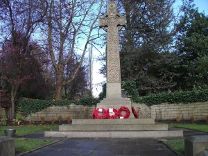
Luddenden Cenotaph – November 2012
Historical Development
Luddenden stands on the millstone grit flanks of the valley of the Luddenden Beck. The earliest settlement clustered about the ford in the valley bottom but later buildings were erected higher up the hillside.
The tightly packed huddle of stone buildings which characterise Luddenden, and many Pennine villages, are man’s historical answer to the geological and climatic conditions of the area.
The origin of the village was the growth of a settlement at the point the pack horse trail from Halifax into Lancashire descended from the hills into the valley to cross Luddenden Brook.
The fast flowing nature of the beck was exploited from early times, and the Warley corn mills were established in the village by 1284.
Before the 15th Century the area was pastoral in nature, but during that century handloom weaving was established. These two activities were dominant until the latter part of the 18th Century.
Up to this date the village was confined to a small cluster of houses at the bridge and the church. By 1820, four water mills were established along the Dean, and terraces of workers’ houses were constructed against the slopes of the hillside.

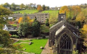
The Parish Church was rebuilt in 1820 in a larger form, this being a clear illustration of the prosperity and growth of the period. In 1842 the first steam powered mill was established at Oats Royd.
The result of this expansion away from the valley bottom was that further development took place on the upper slopes of the valley above the old village, mainly for the Murgatroyd estate.
The construction of the New Road to take coal from the Calder Valley at Luddenden Foot to Oats Royd Mill resulted in a ribbon of development along its line on the upper slopes of the hillside.
Above the village a number of large houses, such as Carr Field, were built. The pattern of historical development has created a compact, enclosed valley bottom village which later developed in a more straggling form up the valley sides.
Surrounding this core are a series of small settlements based around old farmsteads and the New Road. This is set against an undeveloped backdrop of steep hillside fields, large copses of trees and scrub, bounded by dry stone walls.
There is an exceptionally close relationship between the tightly enclosed village and the surrounding and penetrating fields or woods which has survived to the present day.
Role
The historical decline has been checked in recent years as the village has been ‘discovered’ and has taken on a new role as a residential satellite for the Halifax/Sowerby Bridge conurbation. Its picturesque character has also attracted a number of day visitors to stop for a while whilst on their way to Luddenden Dean.
After a long period of gradual decline which left an ageing population, there has been a recent rise due to an influx of young people who live in Luddenden but work in Halifax.
The farming consists of cattle rearing on the lower slopes of the valley, sheep rearing on the upper slopes and the flat moorland beyond its rim.
In recent years some farms have been combined, and the surplus farm-houses, together with their surrounding fields, have been sold to commuters.
In other parts of the valley this has resulted in the fields being allowed to revert to unsightly scrub land, though this has not yet occurred in Luddenden.
Fortunately there has been no removal of dry stone walls to accommodate modern agricultural methods or leisure pursuits.
Character
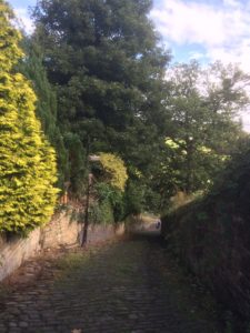
A major feature of the townscape is small enclosed spaces which occur throughout the village linking serially one to another, and affording brief glimpses of the countryside beyond.
They are the essence of the character of Luddenden and this would be lost if they were opened out. If’ the traditional townscape is to survive, it is important that the key physical features, together with the main visual characteristics, are preserved and enhanced.
Despite the village’s long history the oldest surviving building is the early 17th Century Lord Nelson Inn. Parts of Box House Farm on the hill above are probably contemporary with the Lord Nelson. Most of the other old buildings date from between 1780 and 1840.
The houses are simple stone cottages with minimum details to doors and windows, and stone or slate roofs. They possess rows of square mullion windows reminiscent of weavers’ windows.
The overall effect is well suited to the surrounding country, being simple buildings, grouped in a Pennine landscape to which their materials relate closely, composed of the same natural elements as the landscape.
Internally the majority of the cottages are two up and two down with a side staircase.

